Overview
The project team gathered data and performed technical analysis to develop several roadway alternatives. These alternatives were analyzed and presented to the public for input at a public information meeting on September 19, 2019. The Recommended Preferred Alternative and DRAFT Environmental Assessment were presented at the Public Hearing in the summer of 2021. Following the Public Hearing in July 2021, the project team evaluated all feedback received from the public, local governments, and federal and state agencies, and a public information meeting was held in March 2022 to present the modifications made to the Recommended Preferred Alternative based on the results of feedback received. The revised alternative is referred to as the Modified Recommended Preferred Alternative. Based on public comment from the March 2022 public meeting and subsequent feedback from the Town of Hilton Head Island, the Modified Recommended Preferred Alternative was revised in 2024 to further reduce right-of-way impacts to the Stoney Community. Scroll to view the selected alternative below.
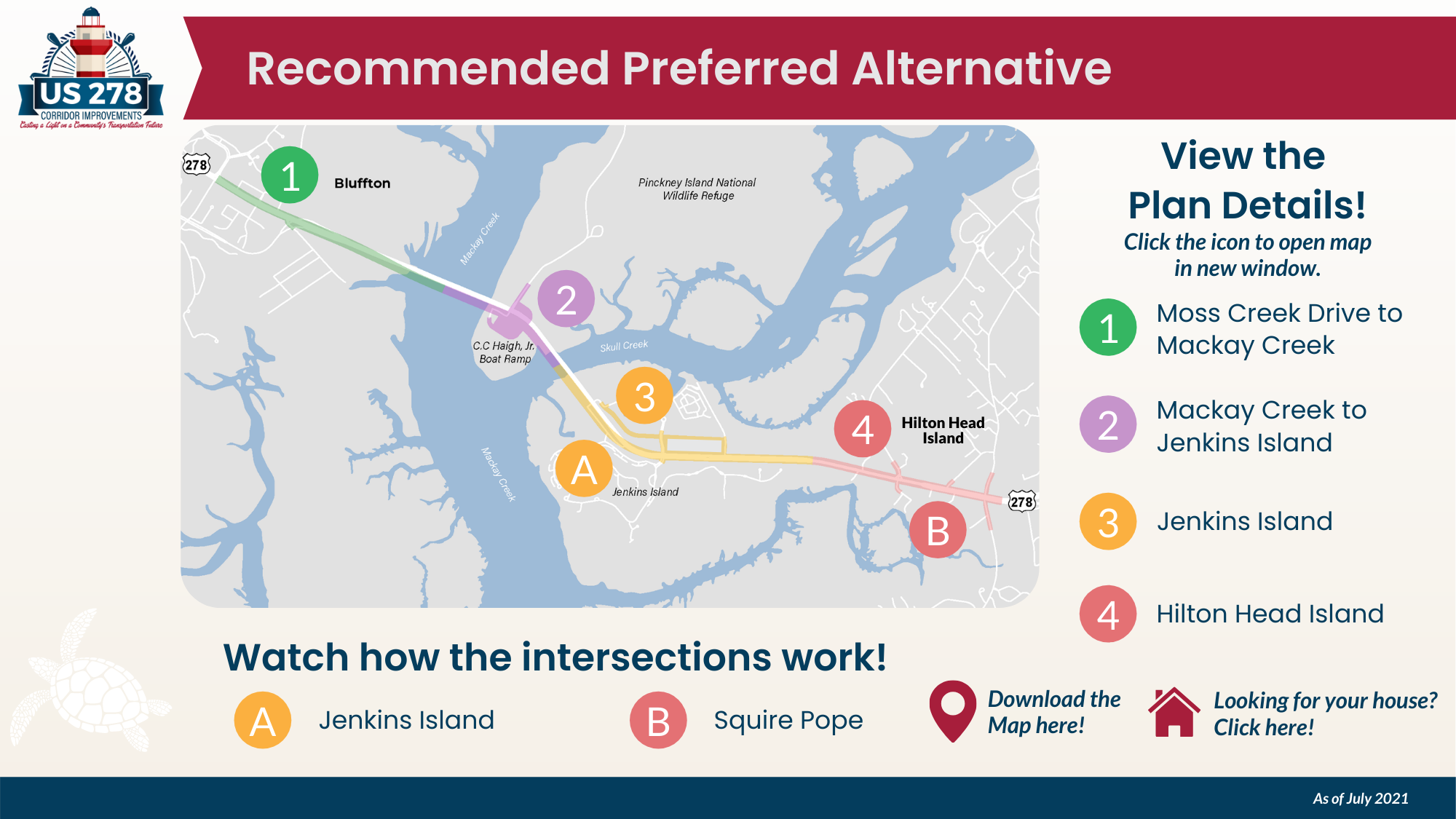
Selected Alternative (Pending FHWA Approval)
2024 MODIFICATIONS INCLUDE:
Removed one of two right turn lanes from Squire Pope Road onto US 278 toward Bluffton
Removed one of two left turns from US 278 onto Squire Pope Road
VIEW DETAILED MAPS OF THE MODIFICATIONS:
Map of Selected Alternative on Hilton Head Island (Compare to 2022 Modified Recommended Preferred Alternative)
Right-of-Way Comparisons
tHE US 278 EASTBOUND BRIDGE REPLACEMENT Project
The proposed project, now called the selected alternative, includes:
Replacement of all 4 bridges along US 278 between Bluffton and Hilton Head Island with a single, new 6-lane bridge immediately south of the existing bridges which includes:
A reduced inside shoulder from 10’ to 6’
Improved access to Pinckney Island National Wildlife Refuge and the C.C. Haigh, Jr. Boat Landing and relocation of the boat ramp to the north side of US 278
Addition of 1 travel lane in each direction throughout the corridor
Of the 6 total lanes along US 278 between the Crazy Crab and Spanish Wells Road, the inner 4 lanes would be reduced to 11 feet to create a traffic calming effect within the Stoney Community
Several interchange improvements to enhance the flow of vehicles
Removing the Jenkins Road intersection with US 278; traffic would be rerouted to C. Heinrichs Circle
Retaining the single right turn from Squire Pope onto US 278 toward Bluffton and the single left turn from US 278 onto Squire Pope
Retaining the existing left turn from US 278 onto Wild Horse Road
Providing dual left turns from Spanish Wells Road onto US 278 toward Bluffton
The intersection with Old Wild Horse Road would stay as it is currently
Modified Recommended Preferred Alternative (2022)
PROPOSED MODIFICATIONS INCLUDE:
Removing the Jenkins Road intersection and rerouting to C. Heinrichs Circle
Adding dual left turns from US 278 onto Squire Pope Road
Retaining left turns from US 278 at Wild Horse Road and adding dual left turns at Spanish Wells Road
Reducing the width of the inside 4 lanes between the Crazy Crab and Spanish Wells Road along the Stoney Community
Meander the westbound lanes of US 278 on Jenkins Island to create a parkway effect
Adding a scenic look-out point along the multi-use path over each creek
VIEW DETAILED MAPS OF THE PROPOSED MODIFICATIONS:
Map of Full Modified Preferred Alternative (Compare to Recommended Preferred Alternative 4A shown at the 2021 Public Hearing Here)
Map of Modified Preferred Alternative on Jenkins Island (Compare to Recommended Preferred Alternative 4A shown at the 2021 Public Hearing Here)
Map of Modified Preferred Alternative on Hilton Head Island (Compare to Recommended Preferred Alternative 4A shown at the 2021 Public Hearing Here)
Recommended Preferred Alternative 4A (as shown at the 2021 Public Hearing)
Recommended Preferred Alternative (as presented at the July 2021 Public Hearing)
The Recommended Preferred Alternative, Alternative 4A, was presented as part of the July 2021 Public Hearing. It would replace all 4 existing bridges with one new bridge immediately south of the existing bridges. After exiting from the new bridge, heading from Bluffton to Hilton Head Island, you would continue onto the current US 278 alignment. Intersection improvements would be made at C Heinrichs Circle, Jenkins Road, Squire Pope Road, Old Wild Horse Road, and Wild Horse Road/Spanish Wells Road.
Based on recommendations from the public and MKSK; SCDOT, Beaufort County, and the Town of Hilton Head Island are continuing to evaluate the section of US 278 between Crosstree Drive/C. Heinrichs Circle and Spanish Wells Road/Wild Horse Road. The results of this analysis will be presented at an additional Public Information Meeting in 2022.
Click the image to view detailed maps of the Recommended Preferred Alternative study area segments, intersection traffic simulation videos, and an interactive right-of-way map.
Reasonable Alternatives
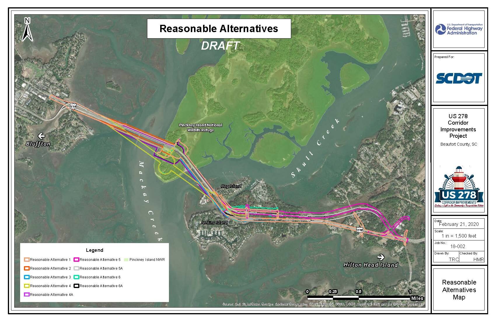
Proposed Reasonable Alternatives Overview
The Preliminary Range of Alternatives and the Proposed Reasonable Alternatives were presented to the public at a Public Information Meeting on September 19, 2019. Based on input received from the public and agencies, the Proposed Reasonable Alternatives were revised to include the following:
Coordination with US Fish and Wildlife Service regarding the six Proposed Reasonable Alternatives (RA1-6) resulted in a revision to Alternative 4 that moved the proposed interchange on Pinckney Island closer to the existing US 278 Corridor. This revision resulted in a new alternative, Alternative 4A.
Alternative 5 and Alternative 6 utilize the existing Power Line Easement to relocate US 278 to a new 6-through-lane (travel lane) section from the end of the new Skull Creek Bridges through Jenkins Island. Based on input from the utility companies, these two alternatives were revised to run south of the existing power line easement across Jenkins Island. These revisions resulted in two new alternatives, Alternative 5A and Alternative 6A.
All of the Proposed Reasonable Alternatives, except for Alternative 5, were revised to provide more efficient ingress/egress to properties on Hog Island. In addition, the revised Hog Island access allows for an improved maintenance of traffic during construction. Figure 5-2 illustrates the ingress/egress developed for Alternative 2 which is representative of all the Proposed Reasonable Alternatives, except for Alternative 5.
Based on the public input and the revisions explained above, the six (6) reasonable alternatives were revised to nine (9) Proposed Reasonable Alternatives shown below, with the new alternatives denoted with “A” in the name following the number.

Reasonable Alternative 1 (RA1)
Build new eastbound Mackay Creek bridge south of the existing bridge
Recondition and widen existing westbound Mackay Creek bridge
Recondition and possibly widen Skull Creek bridges
Use existing alignment as much as possible

Reasonable Alternative 2 (RA2)
Build a new bridge to the north of existing westbound Mackay Creek bridge
Recondition existing westbound Mackay Creek bridge and convert to eastbound traffic
Use newly constructed bridge for westbound traffic over Mackay Creek
Recondition and possibly widen Skull Creek bridges

Reasonable Alternative 3 (RA3)
Build 2 new eastbound bridges south of the existing alignments, one over Mackay Creek and one over Skull Creek
Recondition and widen westbound Mackay Creek Bridge
Recondition existing Skull Creek Bridges and convert to westbound traffic only

Reasonable Alternative 4 (RA4)
Replace all 4 existing bridges with one new bridge immediately south of the existing alignment
Build a new access to the Pinckney Island National Wildlife Refuge and CC Haigh Jr. Boat Ramp
Use existing alignment east of the new bridges
Remove existing bridges

Reasonable Alternative 4A (RA4A)
Same as RA4 but revised based on Public and Agency Feedback, See above
Replace all 4 existing bridges with one new bridge immediately south of the existing alignment
Build a new access to the Pinckney Island National Wildlife Refuge and CC Haigh Jr. Boat Ramp
Use existing alignment east of the new bridges
Remove existing bridges
Reasonable Alternative 5 (RA5)
Build 2 new eastbound bridges just south of the existing
Recondition westbound bridges and widen in place
Improve access to the Pinckney Island National Wildlife Refuge and CC Haigh Jr. Boat Ramp
Utilize the existing transmission line easement running from Jenkins Island through Spanish Wells Road

Reasonable Alternative 5A (RA5A)
Same as RA5, but revised based on Public and Agency Feedback, See above
Build 2 new eastbound bridges just south of the existing
Recondition westbound bridges and widen in place
Improve access to the Pinckney Island National Wildlife Refuge and CC Haigh Jr. Boat Ramp
Utilizing property adjacent to, but just south of, the existing transmission line easement for US 278 running from Jenkins Island through Spanish Wells Road
Remove existing bridges

Reasonable Alternative 6 (RA6)
Replace all 4 existing bridges with one new bridge just south of the existing US 278 alignment
Build a new access to the Pinckney Island National Wildlife Refuge and CC Haigh Jr. Boat Ramp
Utilize the existing transmission line easement running from Jenkins Island through Spanish Wells Road
Remove existing bridges

Reasonable Alternative 6A (RA6A)
Same as RA6, but revised based on Public and Agency Feedback, See above
Replace all 4 existing bridges with one new bridge just south of the existing US 278 alignment
Build a new access to the Pinckney Island National Wildlife Refuge and CC Haigh Jr. Boat Ramp
Utilizing property adjacent to, but just south of, the existing transmission line easement for US 278 running from Jenkins Island through Spanish Wells Road
Remove existing bridges
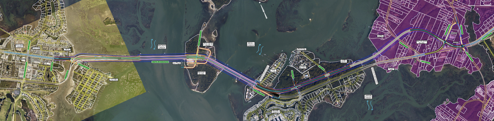
Preliminary Range of Alternatives

Preliminary Range of Alternatives
Incorporating feedback from the community along with known constraints and challenges, the engineering team developed 17 alternatives called the “Preliminary Range of Alternatives” shown on this map. These 17 alternatives were systematically evaluated using the criteria in the Alternatives Evaluation Criteria Matrix to determine the Reasonable Alternatives. These criteria include the projected number of properties that may be impacted, as well as potential impacts to neighborhoods, protected lands and wetlands. Potential impacts were quantified using Geographical Information Systems (GIS) and the best available data from federal, state and local government sources. Those preliminary alternatives that moved forward as the recommended preferred alternatives are shown in pale yellow on the map to the right.